Hohgant/ Furggengütsch HB/BE-131 12.10.2023

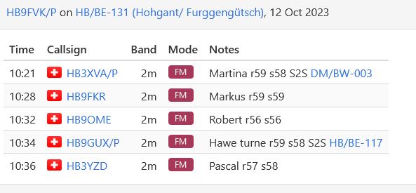
I did not a lot of activation’s this year, but my main target has been to reach 250 point, still far away from a GOAT, but a milestone. As two friends asked if a join them for a hike to Hohgant/ Furggengütsch, i said immediately yes. This summit is located in the Emmental Alps and the summit is called Hoghant. We went by car and left the Car at the Parkinglot called Schwarzbach (46.762969, 7.901317), Details for this hike can be found here. For this activation i toke only a 2m Handheld with me, to be as light as possible for this heavy hike. I worked 5 swiss Stations, even two S2S. I was happy, i got my needed 8 points.


Total distance: 9564 m
Total climbing: 745 m
Download file: rundumdenhohgant.gpx


thank you for QSO, 73 de hb9fvk (ruedi)

Spicher HB/SG-039 09.09.2023

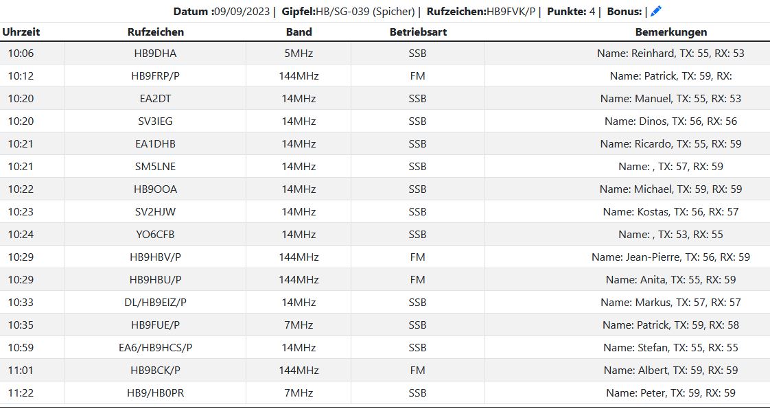
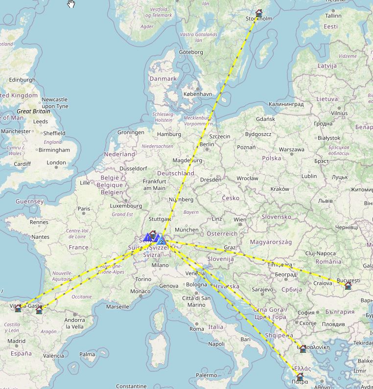
Today was the HB9SOTA Hiking Day in the Eastern Part of Switzerland. There are a lot of summits, that can be reached from Schwägalp Pass. There is even a easy one, Säntis that can be reached by a Cableway. i chose Spicher with an altitude of  1520m asl. I belive i had the longest trip to get there, more than 3 hours by public transport. The hike it self is easy with some Moreland, that was not so wet, i walk over Roots and wet grass. The rest is easy going. My main target was to get a lot of S2S. Later we met at the Restaurant and had a Drink all together.


Total distance: 4029 m
Total climbing: 330 m
Download file: spicher_hbsg039.gpx


thank you for QSO, 73 de hb9fvk (ruedi)
Furggelenstock HB/SZ-025 22.08.2023

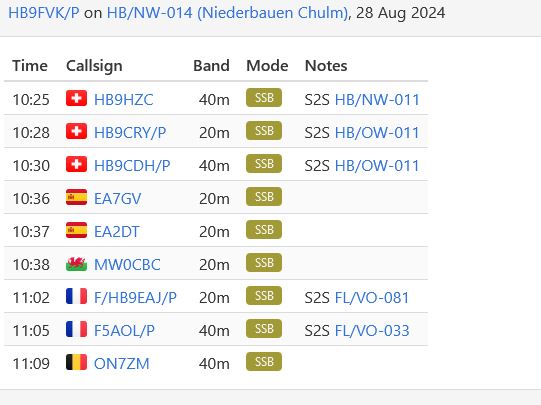
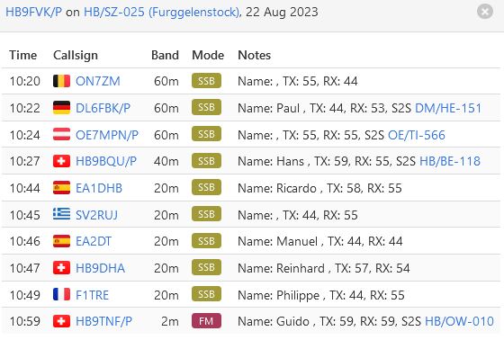
I did not have a lot of time  for SOTA this year, but i was so hot, i wanted to go to a cooler place. Well it was cooler, but the sun was still burning like hell. By public transport you can reach Ibergeregg very easily. This pass is well known by Biker and their heavy Motorcycles. Anyway, i had to walk up to Furggelenstock and do some work up there.
During the hike i often was seeking for shadow by nearby trees. Al of sudden i was looking at a cow, that was hidden in the tree, seeking shadow as well i guess. Later i meet a young boy, explaining he is checking his cattle, there shall be 52 of them, i wished him good luck and walked on. Later i head a very loud whistle and all the cattle cam from all over the place.
at the summit there was an two Alpenzeiger, they were like a roof and one could sit underneath in the shadow. I was happy with this. On the hike back there was a sign, do not cross a herd of cows, but there was no other way back to where i started. So i walked right trough this small herd of cows. i belive they where to tired to move..


Total distance: 2890 m
Total climbing: 315 m
Download file: furgellenstock_hb_sz_025.gpx


thank you for QSO, 73 de hb9fvk (ruedi)
Miesenstock HB/OW-020 17.06.2023

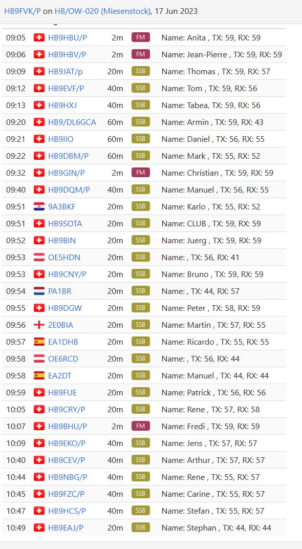
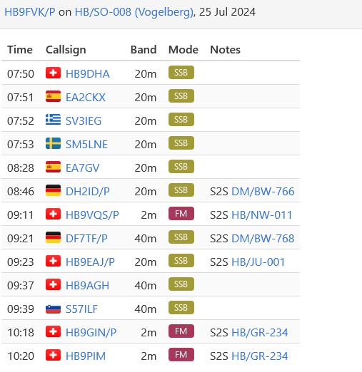
Today is National Summit Activation Day in HB Land, this time i selected a summit closer to my QTH as the last years summit. My Junior joined me to this activation. He picked me up in Lucern and we drove to Glaubenberg Pass. From here we started our hike to the Summit. After i setup the antenna i checked immediately for S2S, most wanted during this activation day.  As you may see, i got a lot of them.  HI. I was sitting on a brand new Bench, even the builder of the Bench showed up and took photos from an OM during an activation.  Back at the Restaurant we ate a Mandelgipfel, according the Barkeeper, the best all over Switzerland. They were still warm and tasted excellent.


Total distance: 3684 m
Total climbing: 381 m
Download file: miesenstock_hb_ow_020.gpx


thank you for QSO, 73 de hb9fvk (ruedi)
Rinderberg HB/BE-106 09.02.2023

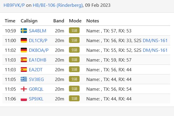
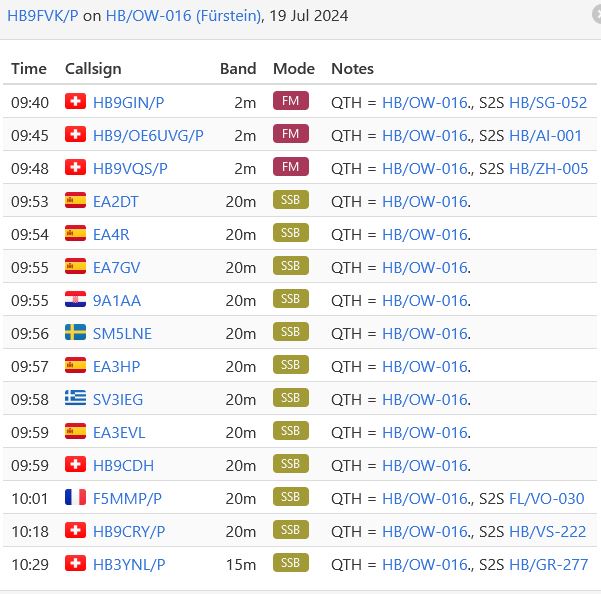
I finally got some spare time to activate a summit and get some Bonus Points. Rinderberg is located in Zweisimmen and easy reachable by public transport. After a short walk you get to the Gondola Lift up to Rinderhorn. From the restaurant there is a short hike to the top. Get good boots, the snow was already frozen. After work i put my Crampons to get down this steep hill. Once down i got a hot coffee on the Restaurant and went back down by the Gondola Lift.


Total distance: 373 m
Total climbing: 74 m
Download file: rinderberghb_be_106.gpx


thank you for QSO, 73 de hb9fvk (ruedi)
Le Chamossaire HB/VD-020 | Chaux Ronde HB/VD-024 18.10.2022

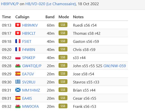
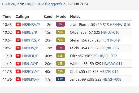
Today i wanted to activate two summits in the Canton Vaud. It’s a french speaking area and the place where i’am going is well known for skiing. By public transport (train and bus) i got to Villars sur Ollon. Further on by a train, i arrived at Col de Bretaye, after four hour of travel. From the Station you may see on of the summits, it has a Chairlift on top of Le Chamossaire . The hike is short but step, approximately 19% positive slope. Well at the end i got to the summit and installed my gear, toke some pictures and started working the bands. Since i wanted to activate a second summit i left and walked down to the Station again to hike the second summit.


Total distance: 1548 m
Total climbing: 302 m
Download file: hbvd020.gpx


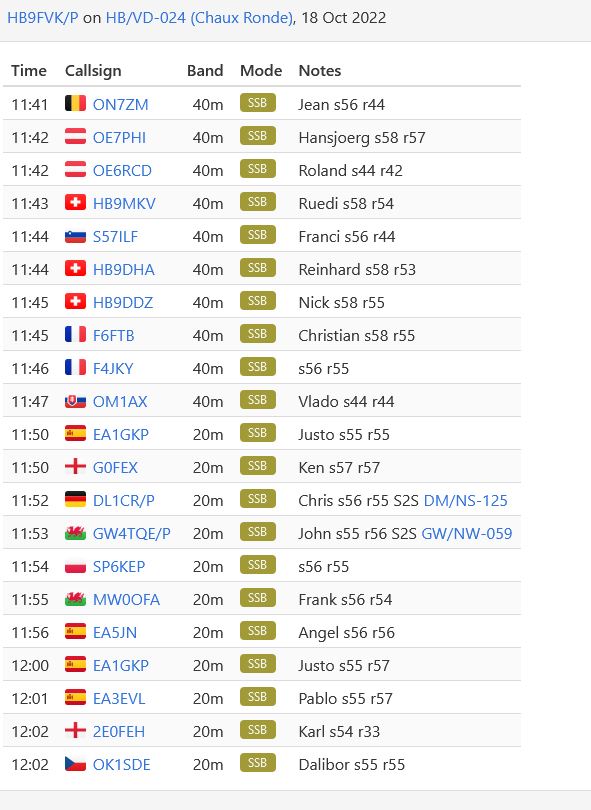
The first part of the hike, just follow the Service road for the Chairlift station at the Top of lower summit of Chaux Ronde 1988m.s.l.Until the season 2021-2022 there was an old Ski lift. The are building a brand new Chair Lift from Lac Noir to Chaux Ronde. I should be ready for next Winter season. Check the pictures.

The real summit has 2028 m.s.l., there is no official hike up there. Just walk as you like. Once there is a flat plateau, with enough space to setup any kind of antenna. It was fun working here, a lot of QSO’s in no time. After all it was a long day, i was twelve hours on tour. But happy with 18 more point.


Total distance: 2556 m
Total climbing: 284 m
Download file: hbvd024.gpx


thank you for QSO, 73 de hb9fvk (ruedi)
Musenalper Grat HB/NW-017 06.10.2022

Our target today for my XYL and me is the Musenalper Grat. We took the easy way to get to the Top. There are two different Cable Cars. First from Niederrickenbach Station to Niederrickenbach Dorf , from here with a small Cable Car to the Summit.  Once at the top, there is a short walk to the Activation Zone. All of a sudden a cool wind showed up and my XYL wanted to have a Drink in the Alpbeizli. We took a Glas of white wine and since i had some cold fingers i took a special coffee Zwetschgen Luz. A Hot coffee in a Glass, few coffee and more schnaps. They bring the coffee and put the Bottle with the schnaps on the Table, you may server your self.

After the break we walked down to Niederrickenbach Dorf and from there back home by Public Transport


thank you for QSO, 73 de hb9fvk (ruedi)
Arnihaaggen HB/OW-027|Brienzer Rothorn HB/OW-010 23.09.2022

The plan for today was to activate two summits in the Canton Obwalden.  The easy one is HB/OW-010, just by the Cable Car and some steps to the top. But first i wanted to activate HB/OW-027. From the Cable Car Station you have to hike down to Eisee. From there it’s a nice hike up to Arnihaaggen. There is plenty space to setup an antenna. Later i went down to Eisee Restaurant to get a refreshment. Bach to Rothorn i took the Chair Lift.


Total distance: 2824 m
Total climbing: 209 m
Download file: arnihaagenow027.gpx


Each side of the Brienzer Rothorn claim it’s our Summit, Lucerne and Berne. But the summit itself lies in a three canton corner and the Peak belongs to Obwald. The Rothorn is easy accessibly by Public Transport and a Cable Car. A short walk brings you to the summit. During Wintertime this is well know spot for Sports.


Total distance: 359 m
Total climbing: 58 m
Download file: brienzerrothornow010.gpx


thank you for QSO, 73 de hb9fvk (ruedi)
Sonnebergwald HB/LU-028 22.09.2022

My planing for today was to activate Chingstuel, near the Brünig Pass. The summit can be reached via Cable Car and 70 minutes hike, rated T3 according SAC.  At the station i asked for tickets, Sorry, but the Cable Car does not work today, coma back tomorrow.  Well i didn’t calculated with that one, since the Swiss Rail App told me, all okay. Since i was going back to Lucerne, i decided to activate Sonnebergwald, instead. By public transport i got to Kriens, where the hike starts. You may go up by a Retro Funicular, The schedule for today was not my friend, therefore i had to hike to the summit. At the beginning of the  hike you get some nice stairs, later it’s a nice trail, T1, no problems. At the top you see the top station of the funicular. From there it’s still 2km to go. The activation is flat surrounded by high trees. Easy to setup an antenna. Happy SOTA.

Total distance: 3756 m
Total climbing: 328 m
Download file: lu028sonnenbergwald.gpx


thank you for QSO, 73 de hb9fvk (ruedi)
Landsbärg HB/TG-006|Burstel/Haselberg HB/TG-004 26.07.2022

Today i want to activate 2 small summits in the Canton Thurgau. This place is well known for its Apple Trees and the Cider, called Most ins Swiss German dialect. Therefore if you talk from Thurgau people say often MostIndien. I went to Gunterhausen by Train. The hike to HB/TG-004 started directly at the Station, first trough meadow before entering the forest. Its an easy walk , after one hour you are at the top of the hill. The activation zone is a small corridor between the trees, just enough to hang a wire into the trees. Within a short time i got some nice contacts. Soon after i walked back to the Train Station to move on to the next Summit.

Total distance: 2128 m
Total climbing: 267 m
Download file: tg004burstel.gpx


By train to Eschlikon and from there by Bus to


Total distance: 1502 m
Total climbing: 158 m
Download file: tg006landsbarg.gpx


thank you for QSO, 73 de hb9fvk (ruedi)